• Geographic coordinates, how do they work?

Imagine being able to pinpoint any location on the Earth without ever leaving your seat.

There’s no need to daydream because, thanks to geographic coordinates, this is now a reality. This system has evolved from the astrolabes used by early navigators to the modern GPS technology in our smartphones.

But what exactly are geographic coordinates? How are they defined, and why should they pique your interest? Keep reading, as we’re about to dive deep into this topic.

First off, what are geographic coordinates?

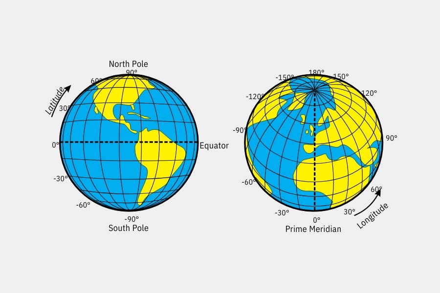
Geographic coordinates are a system used to specify any location on Earth’s surface through two numerical values: latitude and longitude.

Latitude refers to the horizontal lines that stretch from east to west, measured in degrees, minutes, and seconds. Longitude, on the other hand, corresponds to the vertical lines that run from north to south, also quantified in degrees, minutes, and seconds.

Think of geographic coordinates as universal addresses, unaffected by languages or dialects; they are a mathematical language that lets us share precise locations with anyone worldwide. And why is this significant?

Understanding geographic coordinates has always been crucial, not just for travellers and explorers but also for scientists, geographers, and virtually anyone using a map or GPS. They enable everything from flight planning to conducting precise environmental and geological studies.

Do you now see the significance of geographic coordinates? Without them, exploring our planet’s vastness and discovering its wonders would be impossible.

Components of Geographic Coordinates

Latitude

Latitude pertains to the imaginary horizontal lines running from east to west, known as parallels.

Originating from the Equator, deemed the zero parallel that bisects our planet into the northern and southern hemispheres, latitude helps determine a point’s vertical position on the Earth’s surface. It is measured in degrees (°), minutes (‘), and seconds (“), ranging from 0° at the Equator to 90° at the poles.

Beyond navigation, latitude is vital for understanding climate, daylight hours, and seasonal changes globally. Have you ever wondered why the climate shifts as you move away from the Equator or why seasons are reversed in the opposite hemisphere? Yes, latitude is key to comprehending this.

Lattitude and longitude, crucial to geographic coordinates

Longitude

Conversely, longitude is determined by imaginary vertical lines that traverse the Earth from north to south, called meridians. This helps us define a horizontal position east or west of the primary or zero meridian, known as the Greenwich Meridian.

Like latitude, longitude is measured in degrees, minutes, and seconds, from 0° in Greenwich (England) to 180° on the globe’s opposite side.

Moreover, longitude is crucial for determining time zones. Every degree of longitude equates to about four minutes of time. Thus, as we travel around the world, we adjust our watches according to these divisions to maintain accurate local time. If you’re interested, there’s more to learn in our post about UTC or Coordinated Universal Time.

Geographic coordinates in decimal format

Aside from the traditional degree, minute, and second format, geographic coordinates can also be expressed in decimal format. Unlike the traditional format, which divides each degree into minutes and seconds, the decimal format represents latitude and longitude as single decimal numbers.

This not only makes them easier to read and understand but also simplifies their use in mathematical calculations and digital applications, providing precision and readability suited for our times.

Converting geographic coordinates to decimal format

Converting geographic coordinates to decimal format is straightforward: each degree is divided into 60 minutes, and each minute into 60 seconds, right?

By converting these values into a decimal fraction of a degree, the need to work with minutes and seconds is eliminated, resulting in a much simpler and manageable location representation. For instance, a latitude of 40º, 30′ (40 degrees, 30 minutes) converts to 40.5º in decimal format.

This method is not only more efficient for inputting data into GPS navigators or digital mapping systems; it also enhances location accuracy by allowing for longer decimal extensions.

Now you know a bit more about geography and navigation

We hope you enjoyed this post and, more importantly, learned about the pivotal role geographic coordinates have played in humanity’s development.

Moreover, they have countless applications in our daily lives, from personal navigation and urban planning to studying atmospheric phenomena. Indeed, it’s hard to think of any field of study where geographic coordinates don’t play a crucial role.

And remember, if you enjoy reading and learning about aviation (and countless related topics), we invite you to explore our aviation blog, where we discuss everything from how airspace is divided to the Coriolis effect. You won’t want to miss it!

You may be interested…